


2021 08 BAGNOLS T2

michel1025
User
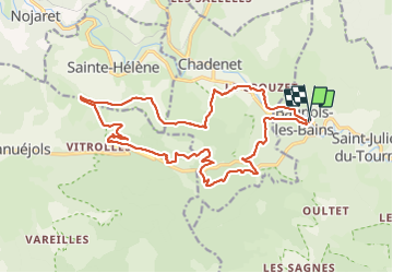

Length
22 km

Max alt
1251 m

Uphill gradient
725 m
Km-Effort
31 km

Min alt
889 m

Downhill gradient
727 m
Boucle
Yes
Creation date :
2021-08-10 07:00:16.0
Updated on :
2021-08-10 15:25:30.814
7h23
Difficulty : Very difficult

FREE GPS app for hiking
 SityTrail
IGN / Geographical institutes
SityTrail Plus
The world is yours!
About
Trail Walking of 22 km to be discovered at Occitania, Lozère, Mont Lozère et Goulet. This trail is proposed by michel1025.
Positioning
Country:
France
Region :
Occitania
Department/Province :
Lozère
Municipality :
Mont Lozère et Goulet
Location:
Unknown
Start:(Dec)
Start:(UTM)
552808 ; 4928351 (31T) N.
Comments